Take a step back in time and stand face-to-face with the origin of The Bahamas – see the archeological evidence of the indigenous Lucayan Indians, the multiple monuments commemorating Columbus’ landfall in the New World, and the present carved from the past!
- Landfall Park (Columbus’s landing spot)
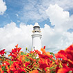
- Dixon Hill Lighthouse (built in 1887)
- Pigeon Creek lagoon tours
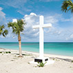
San Salvador has been recognized – with much debate amongst researchers – as Christopher Columbus’ first landfall in the New World in 1492. To date, four separate monuments mark the ‘exact’ spot where he came ashore; however, it is generally recognized that the landing occurred at Long Bay, currently commemorated by a simple white stone cross.
Named Guanahani by the original native inhabitants – the Lucayan Indians – Columbus promptly renamed the island San Salvador or ‘Holy Savior’. Later, San Salvador was taken over by the British buccaneer, George Watling who renamed the island Watling’s Island after himself. It was not until 1926 that the island’s name was restored to San Salvador which it remains to this day.
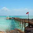
Set on the Atlantic side of the archipelago of The Bahamas, the island of San Salvador is about 200 miles southeast of Nassau, about a 1-hour flight from Florida. The island’s capital, Cockburn Town, is located on the tranquil west coast of San Salvador. One of the most southeastern islands of The Bahamas, San Salvador is actually the exposed peak of a submerged mountain that rises 15,000 feet from the ocean floor. Only 12 miles long and 5 miles wide with a population of 1,200 San Salvadorians, the island has miles of pristine and secluded beaches and emerald blue sea. San Salvador mostly consists of dune ridges, with troughs forming sparkling lakes that make up nearly a third of the interior of the island. Surrounding reefs protect the island and a large break near Cockburn Town, provides access to the island for boats.
Rum Cay, San Salvador's smaller and more sparsely populated sister island, is located 20 miles southwest of San Salvador. It is a relatively flat island with a few rolling hills, the highest of which reaches an altitude of about 120 feet. Originally named Santa Maria de la Conception by Columbus, the present moniker of Rum Cay is said to be in memory of a wreck destroyed with a cargo of rum which foundered off the coral reefs which abound the island's shore.
In the north there is a cave containing Lucayan Indian drawings and carvings and various artifacts from the Arawak Indian period have been found by farmers in the fertile soil, which the Indians enriched with bat guano. As with other islands, Rum Cay has seen a series of economic peaks - pineapple, salt and sisal have all been important industries; however, competition and natural disasters destroyed them and today tourism is the main source of employment. Today, nearly everybody lives in Port Nelson, the main settlement, where cottages can be rented. Settlements such as Port Boyd, Black Rock and Gin Hill are now deserted and overgrown.